
News Releases
As a result of increased interest, the financing was oversubscribed for gross proceeds of $203,580.00 raised above market through the sale of 2,262,000 units at a price of $0.09 per unit (each a “Unit”). Each Unit comprised one common share and one share purchase warrant. Each warrant entitles the holder to purchase a further common share at a price of $0.15 per share until May 25, 2021. The warrants are subject to accelerated exercise provisions such that if the closing price of the Company’s common shares exceeds $0.25 per share for a period of 20 consecutive trading days, the Company may give notice of the acceleration of the warrants’ term to a period of 30 days following such notice.
No finder’s fees were payable in connection with the Placement.
All securities issued in the first tranche are subject to a hold period in Canada expiring on September 26, 2018. Additional restrictions may apply pursuant to Rule 144 of the Securities Act of 1933, as amended, to U.S. investors.
Proceeds of the Placement will be applied to exploration programs for the Company’s Fiji properties and general working capital.
About Thunderstruck Resources
Thunderstruck Resources is a Canadian mineral exploration company that has assembled extensive and highly prospective properties in Fiji on which recent and previous exploration has confirmed VMS, copper and precious metals mineralization. The Company provides investors with exposure to a diverse portfolio of exploration stage projects with potential for zinc, copper, gold and silver in a politically safe and stable jurisdiction. Thunderstruck trades on the Toronto Venture Exchange (TSX-V) under the symbol "AWE".
For additional information, please contact:
Bryce Bradley, President, Chief Executive Officer and Director
Telephone: (604) 349-8119
Email:
or, visit our website: http://www.thunderstruck.ca
Neither the TSX Venture Exchange Inc. nor its Regulation Services Provider (as that term is defined in the policies of the TSX Venture Exchange) accepts responsibility for the adequacy or accuracy of this release.
A Large Porphyry System, a Broad Gold Mineralized Zone and a Zinc-Copper Zone Are Included Among Targets Now Being Worked
Vancouver, British Columbia--(Newsfile Corp. - May 17, 2018) - Thunderstruck Resources Ltd. (TSXV: AWE) (The "Company" or "Thunderstruck") is pleased to announce that field operations are well underway on its 100% owned high grade zinc, copper and gold assets in Viti Levu, Fiji. The present work is building on extensive prior results that point to the potential for large mineralized systems.
"Our exploration season is now in full swing, and we have initiated multiple exploration activities across all of our four primary assets," commented Thunderstruck's President and CEO Bryce Bradley.
"A detailed mapping program of Rama Creek has begun which will follow up on the recent Senikura gold zone discovered nearby. Concurrently, road building into Rama Creek should be completed by the end of May, making it easier to get larger rigs onto the property later in the season. In addition, preliminary mineralogical tests from our Wainaleka VMS project indicate great potential to produce zinc and copper concentrates via conventional flotation, which is a critical precursor to mine development."
"Elsewhere, further work on our high-grade Liwa Creek gold prospect will begin shortly, and we'll be giving all of our zinc, copper and gold assets much deserved attention this season, with plenty of news flow forthcoming. This is the first year that Thunderstruck has had the entire land package under its control and can meaningfully advance the various targets. The enthusiasm around this program has prompted investors to request a private placement, at above market, which we have agreed to."
RAMA CREEK COPPER-GOLD PORPHYRY AND SENIKURA GOLD ZONE
During December 2017, field crews carried out a soil program to determine the limits of the broad copper-gold (Cu-Au) mineralized porphyry intrusive at Rama Creek. Originally discovered by Anglo American in the 1970s, subsequent work, including drilling and trenching, outlined a broad porphyry system. The recent work was successful in establishing a framework of porphyry hydrothermal alteration zonation that is helping to understand the geometry of the system and will serve as a vector to define the core of the mineralized system.
Field crews collected a total of 112 ridge-and-spur auger soil samples that were subsequently submitted for gold and multi-element geochemical and TerraSpec® Short Wave Infrared (SWIR) spectral analysis. Of the 112 auger soil geochemical samples collected over the interpreted extent of the Rama Creek Porphyry, a total of 18 samples returned greater than 50 parts-per-billion (ppb) Au and up to 0.76 grams-per-tonne (g/t) Au; and a total of 31 samples returned greater than 500 parts-per-million (ppm) Cu and up to 0.56% Cu. In conjunction with a previous 126 targeted auger soils collected by the Company, an 18-sample subset of which yielded an average of 0.27% Cu and 0.15 g/t Au (see the Company's March 1, 2018 News Release), the current soil samples define an approximately 1,000 x 600 metre (m) greater than 200 ppm Cu in soil anomaly containing a northwest elongate 500 x 300 m greater than 50 ppb Au in soil geochemical response coincident with the inferred centre of the Rama Creek intrusion (Figures 1 and 2).

Figure 1: 2017 Soil Geochemical Results (Copper) and SWIR Interpretation
To view an enhanced version of Figure 1 please visit:
https://orders.newsfilecorp.com/files/2901/34716_Figure1_Rama_Soils_Cu.jpg
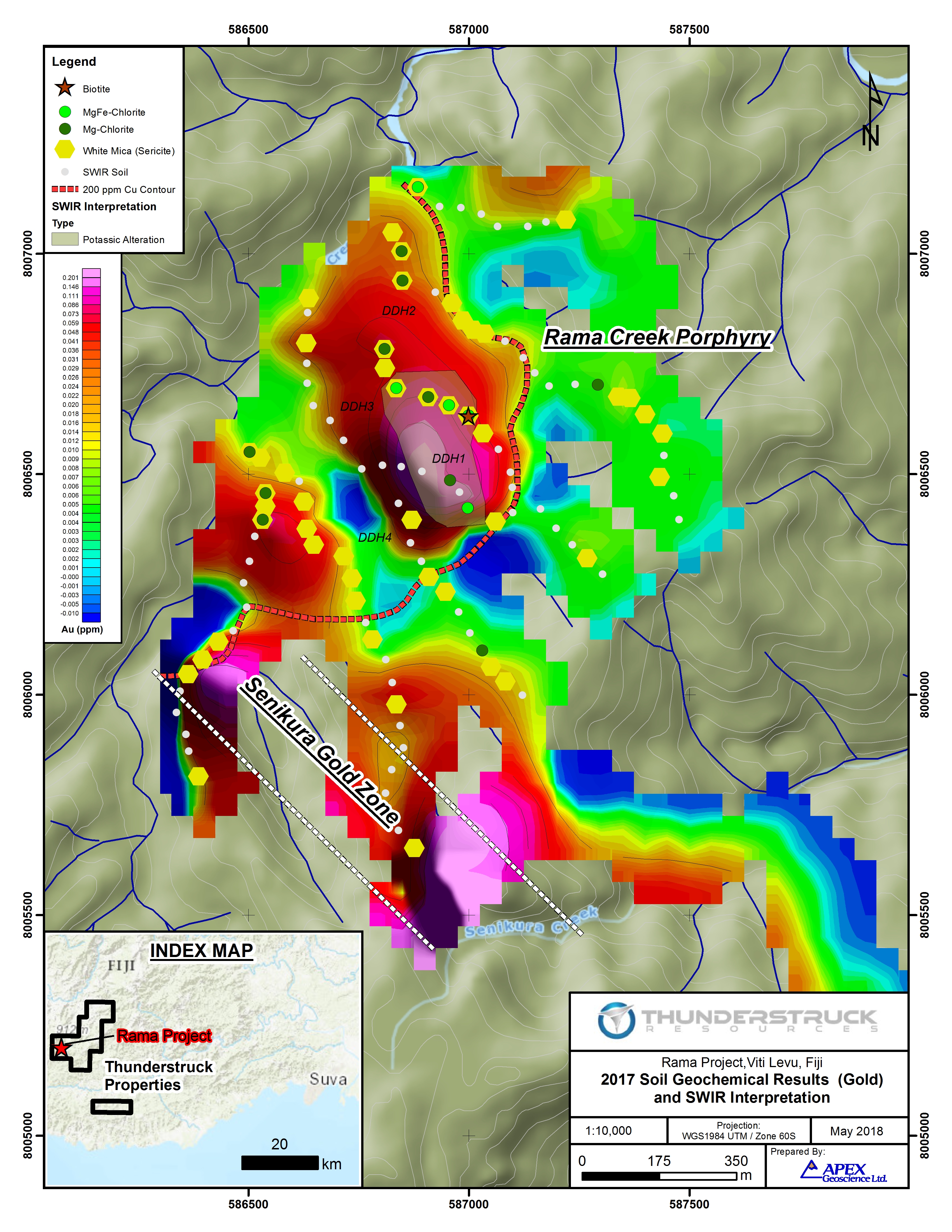
Figure 2: 2017 Soil Geochemical Results (Gold) and SWIR Interpretation
To view an enhanced version of Figure 2, please visit:
https://orders.newsfilecorp.com/files/2901/34716_Figure2_Rama_Soils_Au.jpg
TerraSpec® SWIR spectral analyses define a sericite (white mica) alteration halo that is coincident with the plus-200 ppm Cu in soil geochemical anomaly. The plus-50 ppb Au geochemical target is associated with a northwest elongate magnesium-chlorite spectral response. Gold in soils exceeding 100 ppb (six samples in total) are coincident with a 300 x 200 m area of higher-temperature potassic (magnesium-iron chlorite + biotite) alteration containing historic Australian Anglo American Ltd (Anglo) diamond drill hole "DDH1" that returned a 244-metre interval between depths of 6 and 250 m averaging 0.22% Cu, ending in mineralization (Figures 1 and 2).
Interpretation
The results of the soil geochemical and SWIR spectral analysis program were successful in defining a near-surface expression of porphyry Cu-Au mineralization at Rama Creek. The application of modern SWIR spectral analysis in particular has added critical evidence of porphyry hydrothermal alteration zonation comprising distal weak to moderately chlorite-pyrite altered diorite intrusive and host volcanic rocks, to pervasive proximal sericite and core zone potassic altered porphyry intrusive.
The subsurface geometry and depth extent of the Rama Creek Cu-Au porphyry has not been determined. Historic drilling by Anglo has shown disseminated Cu-Au mineralization extends to a vertical depth of at least 250 m, and is open at depth and in all directions.
In addition to the Rama Creek Porphyry Cu-Au target, the recent soils samples have provided additional resolution on the Company's emerging Senikura Gold Zone target that returned trench rock channel sample results averaging 0.96 g/t Au over 11.1 m (38.5 to 49.6 m), within a broader anomalous gold zone averaging 0.55 g/t Au over 37.6 m (12 to 49.6 m). At a distance of 700 m to the northwest, a series of 10 auger soils spanning the southwest contact zone of the intrusion returned anomalous gold values averaging 0.063 g/t Au (63 ppb Au), including two samples returning 0.1 and 0.2 g/t Au (see the Company's March 1, 2018 News Release). Together these two gold occurrences define an apparently northwest trending gold zone along the margin of the Rama Creek Porphyry that is open to the northwest and southeast into the headwaters of Senikura Creek.
Moving Forward, the Company has commenced road rehabilitation and construction to establish vehicle access to the Rama Creek Prospect in support of 2018 field programs. The present program will include additional Bulk Leach Extractable Gold (BLEG) stream geochemical sampling in the headwaters of Rama Creek to the northwest of the Rama Porphyry and the potential strike extent of Senikura Gold Zone; an expanded auger soil geochemical program designed to test the southeast extent of the Senikura Gold Zone; follow-up on an historic Senikura East gold in soil anomaly located a further 1.5 km to the southeast (12 consecutive 100 m spaced auger soils over 1.2 km returning an average of 67 ppb Au) (see the Company's March 1, 2018 News Release); detailed geologic mapping, prospecting; and Induced Polarization (IP) / Resistivity geophysical surveys towards modelling the subsurface geometry of disseminated Cu-Au bearing sulphide mineralization and generation of finalized diamond drill targets.
WAINALEKA ZINC-COPPER VMS
During March 2018, the Company engaged SGS Canada Inc. (SGS) to complete a QEMSCAN (Quantitative Evaluation of Minerals by Scanning Microscopy) study on a selection of 10 polished mineralized samples from the Company's Wainaleka Zn-Cu VMS (Volcanogenic Massive Sulphide) deposit. The purpose of the QEMSCAN study was to provide information on modal mineralogy, grain size and to provide a preliminary guidance with respect to potential metallurgical performance.
QEMSCAN results (Figure 3) for the 10 samples show a range of sulphide mineral content, with sphalerite, covellite and chalcopyrite being the main minerals of interest. Other sulphide minerals include pyrite, bornite, tetrahedrite/tennanite/enargite, and chalcocite.
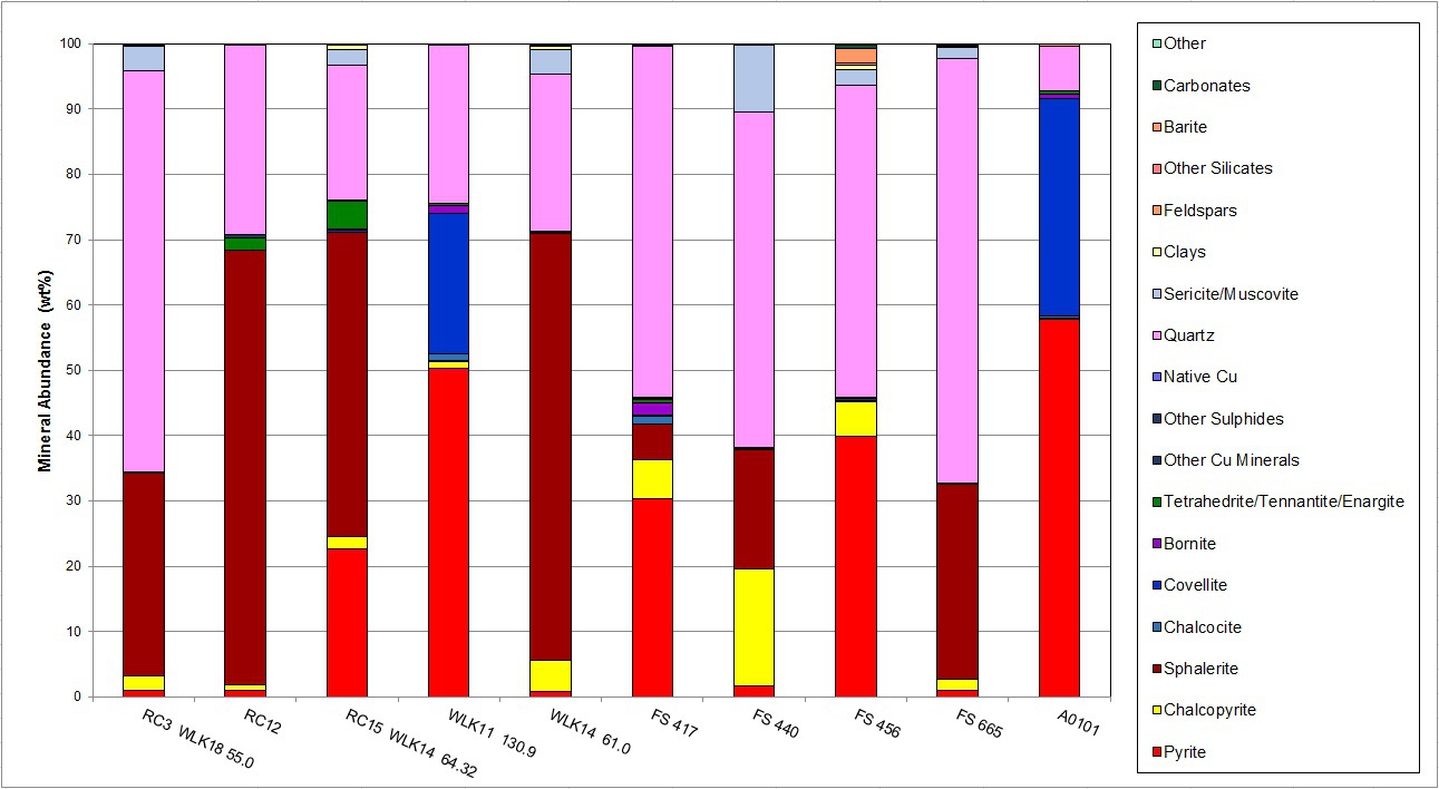
Figure 3: Wainaleka Zn-Cu VMS Modal Mineral Distributions
To view an enhanced version Figure 3, please visit:
[http://orders.newsfilecorp.com/files/2901/34716_a1526568317844_24.jpg]
The 10 samples contained an average of 26.3% modal sphalerite (ranging from 0.1% up to 66.5%); an average of 4.2% chalcopyrite (ranging from 0.1% to 17.9%); and 20.6% pyrite (ranging from 0.9% to 57.7%). Significantly, two samples (RC22 and A0101) collected at a depth of approximately 131 m within drill hole WLK-11 contained 33.3% and 21.4% modal covellite.
With respect to grain size and potential floatation metallurgical performance of the Wainaleka Zn-Cu mineralization, SGS made the following observations:
-
Sequential floatation of copper, then sphalerite into separate concentrates was recommended as a potential processing option for the majority of samples.
-
High zinc content of two samples (greater than 65%) may make them a good candidates for pre-concentration using either dense media of gravity separation.
-
Particle size observed is similar to typical VMS deposits, and suggests a primary grind size of 75 to 100 micron (0.075 to 0.1 mm) should be targeted.
-
With respect to deleterious elements, the observed quantity of non-sulphide gangue minerals should not negatively affect metallurgy. Several reagent schemes and processing conditions can be evaluated to limit recovery of pyrite and arsenic bearing minerals observed in a minority of samples. In addition possible use of zinc depressants, and avoiding blending of high covellite and high zinc or zinc-copper material to limit the potential for high-zinc copper concentrates is suggested.
Interpretation
The Company is encouraged by the results of the preliminary QEMSCAN mineralogical study, which shows the Wainaleka Zn-Cu mineralization appears to have an overall coarse sulphide distribution, making it amenable to sequential flotation. Importantly the study raised the possibility of the creation of a zinc concentrate by relatively low cost dense-media or gravity process methods.
Other important mineralogical observations that warrant further study include: the presence of a subset of high modal percent covellite samples; potential interaction of pyrite in copper primary mineralization; and the presence of a small percentage of copper-antimony-arsenic minerals. In future, the Company intends to investigate various flotation and gravity separation methods, grind size, and reagent (pyrite and zinc suppressor) combinations on fresh drill core samples. The QEMSCAN study represents an important step forward with respect to optimizing subsequent detailed metallurgical studies.
These results are extremely significant in that they provide to potential joint venture partners comfort, on an initial basis, that the material could be processed to produce saleable concentrates.
About the Wainaleka VMS Deposit
During 1977 Australian Anglo American Ltd. (Anglo) completed a 15 hole diamond drill program totaling 1,850 m with holes averaging a relatively shallow 120 m depth that defined the Wainaleka Zn-Cu VMS deposit. Drill hole WLK-1A intersected 9.8 m averaging 8.28% Zn and 1.45% Cu; and drill hole WLK-10 returned 14.1m averaging 1.3% Zn and 1.5% Cu within what has been interpreted as a zone of stringer mineralization. True widths are estimated at 80-100% of the drilled interval. Geologic mapping indicates 15 km prospective geology strike length; including 8 more underexplored Zn-Cu VMS prospects.
During 1980, Anglo commissioned Golder Associates to conduct a review of potential mining scenarios of several Fijian VMS deposits including Wainaleka*. The study published an historic, uncategorized resource for the portion of the Wainaleka Deposit that was tested by the initial drilling of 250,000 tonnes grading 8% Zn and 2% Cu. The resources are considered historic in nature and do not meet the criteria for a National Instrument (NI) 43-101 compliant resource of any category and as such should not be relied upon. Thunderstruck has been unable to verify these sources of information.
*Source: Golder Associates, Review of the Mining Potential of the Fijian Kuroko Style Mineral Discoveries, 1980.
Financing
The Company has arranged a non-brokered private placement to raise up to $150,000 through the sale of up to 1,666,666 units at a price of $0.09 per unit (the "Financing"). Each unit will comprise one common share and one share purchase warrant. Each whole warrant will entitle the holder to purchase a further common share at a price of $0.15 per share for a period of 36 months from closing. The warrants will be subject to accelerated exercise provisions such that if the closing price of Thunderstruck's common shares exceeds $0.25 per share for a period of 20 consecutive trading days, Thunderstruck may give notice of the acceleration of the warrants' term to a period of 30 days following such notice. Proceeds of the Placement will be applied to continuing operations on the Company's Fiji properties and general working capital.
About Thunderstruck Resources
Thunderstruck Resources is a Canadian mineral exploration company that has assembled extensive and highly prospective properties in Fiji on which recent and previous exploration has confirmed VMS, copper and precious metals mineralization. The Company provides investors with exposure to a diverse portfolio of exploration stage projects with potential for zinc, copper, gold and silver in a politically safe and stable jurisdiction. Thunderstruck trades on the Toronto Venture Exchange (TSX-V) under the symbol "AWE".
Qualified Person Statement
Kristopher J. Raffle, P.Geo. (BC) Principal and Consultant of APEX Geoscience Ltd. of Edmonton, AB, is a qualified person for the project as defined by National Instrument NI 43-101. Mr. Raffle has reviewed and approved the portion of the technical content of this news release as it relates to the Rama Creek and Wainaleka Prospects.
During 2017 all Auger soil samples were submitted to Australian Laboratory Services Pty. Ltd (ALS) labs for gold and multi-element geochemical analysis via aqua-regia extraction of a 25 gram (g) sample with ICP-MS finish. SWIR spectra were analysed by ALS using a TerraSpec® 4 High-Resolution Spectrometer on an approximately 100 g plus 2 millimetre coarse soil separate. Spectral interpretation was completed using AusSPec International aiSIRIS™ (Spectral InfraRed Interpretation System) software to produce raw spectral files and output mineral assemblages and relevant spectral parameters. Auger soil samples were collected at a maximum depth of 2 m or to refusal. Given the reconnaissance nature of the samples, Thunderstruck has relied on the external QA/QC of ALS which included the insertion of insertion of standard, blank and duplicate samples at a rate of 10% into the sample stream to confirm the accuracy of the reported results.
QEMSCAN image analysis is able to measure mineralogical variability based on chemistry at the micrometer-scale. It utilizes both back-scattered electron (BSE) signal intensity, as well as Energy Dispersive X-ray Signal (EDS) at each measurement point. QEMSCAN can map many thousands of particles in a polished section to obtain a detailed and statistically robust characterization of the minerals present. It maps the particles based on differences in chemical analysis and can differentiate amongst the various non-opaque gangue present in the ore body.
For additional information, please contact:
Bryce Bradley, President, Chief Executive Officer and Director
Telephone: (604) 349-8119
Email:
or, visit our website: http://www.thunderstruck.ca
Neither the TSX Venture Exchange Inc. nor its Regulation Services Provider (as that term is defined in the policies of the TSX Venture Exchange) accepts responsibility for the adequacy or accuracy of this release.
This news release contains certain statements that may be deemed "forward-looking statements". Although Thunderstruck believes the expectations expressed in such forward-looking statements are based on reasonable assumptions, such statements are not guarantees of future performance and actual results may differ materially from those in forward looking statements. Forward looking statements are based on the beliefs, estimates and opinions of Thunderstruck's management on the date the statements are made. Except as required by law, Thunderstruck undertakes no obligation to update these forward-looking statements in the event that management's beliefs, estimates or opinions, or other factors, should change.
Vancouver, British Columbia--(Newsfile Corp. - March 13, 2018) - Thunderstruck Resources Ltd. (TSXV: AWE) ("Thunderstruck") announces that, further to its press release dated March 1, 2018, it has closed its previously announced non-brokered private placement (the "Placement").
Due to increased interest, the Placement was oversubscribed for gross proceeds of $430,000, raised through the sale of 5,375,000 units at a price of $0.08 per unit (each a "Unit"). Each Unit comprised one common share and one share purchase warrant. Each warrant entitles the holder to purchase a further common share at a price of $0.15 per share until March 13, 2021. The warrants are subject to accelerated exercise provisions such that if the closing price of the Company's common shares exceeds $0.25 per share for a period of 20 consecutive trading days, the Company may give notice of the acceleration of the warrants' term to a period of 30 days following such notice. All securities are subject to a hold period in Canada expiring on July 14, 2018. Additional restrictions may apply pursuant to Rule 144 of the Securities Act of 1933, as amended, to U.S. investors.
No finder's fees were paid.
Insiders of the Company subscribed for a total of 625,000 Units, both directly and indirectly, for aggregate subscription proceeds of $50,000, constituting a "related party transaction" as such term is defined under Multilateral Instrument 61-101 — Protection of Minority Security Holders in Special Transactions ("MI 61-101″). The Company is relying on the exemptions from the formal valuation and minority approval requirements under MI 61- 101. The Company is exempt from the formal valuation and minority approval requirements of MI 61-101 in reliance on sections 5.5(a) and 5.7(1)(a) of MI 61-101 as the fair market value of the transaction, insofar as it involves interested parties, is not more than the 25% of the Company's market capitalization.
The Company has also granted 1,150,000 stock options having an exercise price of $0.09 and a ten-year term to certain of its directors, officers and consultants.
Proceeds of the Placement will be applied to exploration programs for the Company's Fiji properties (geological mapping, sampling, geophysics, further compilation and reporting), and for general working capital.
ADVISORY BOARD
Thunderstruck is pleased to announce the addition of Tookie Angus to the Advisory Board.
For the past 40 years, Mr. Angus has focused on the structuring and financing of significant international exploration, development and mining ventures. Mr. Angus is the former chairman of the board of B.C. Sugar Refinery Ltd.; he was a director of First Quantum Minerals until June 2005, a director of Canico Resources Corp. until its takeover by CVRD in 2005, and a director of Bema Gold until its takeover by Kinross Gold in 2007. More recently, he was managing director of mergers and acquisitions for Endeavour Financial, a director of Ventana Gold until its takeover by AUX Canada Acquisition in 2011, and a director of Plutonic Power until its merger with Magma Energy in 2011. He was until recently Chairman of Nevsun Resources Ltd. He is currently Chairman of K92 Mining and San Marco Resources.
President/CEO Bryce Bradley comments, "We're extremely pleased that Tookie has joined our team. He has been involved in over $8 billion of mergers and acquisitions since 2005. His expertise in contract negotiations, corporate development and strategic partnerships will be very valuable as Thunderstruck evolves into the next phase of our development."
The Thunderstruck properties were explored by Anglo American in the 1970s. Subsequent results, including the recent work by Thunderstruck, have validated the Anglo work and further support the large-scale potential of multiple targets. The Company is presently working toward one or more joint ventures to further advance the VMS and the porphyry gold-copper targets on its property position. Outside of joint-venture initiatives, Thunderstruck will focus on its Liwa Creek epithermal gold-silver prospect, where multi-gram gold and silver values were recently confirmed in surface samples over an area of 3km by 3km in a geological setting similar to that which hosts large gold deposits in that region.
For additional information, please contact:
Bryce Bradley, President, Chief Executive Officer and Director
Telephone: (604) 349-8119
Email:
or, visit our website: http://www.thunderstruck.ca
Neither the TSX Venture Exchange Inc. nor its Regulation Services Provider (as that term is defined in the policies of the TSX Venture Exchange) accepts responsibility for the adequacy or accuracy of this release.
This news release contains certain statements that may be deemed "forward-looking statements". Although Thunderstruck believes the expectations expressed in such forward-looking statements are based on reasonable assumptions, such statements are not guarantees of future performance and actual results may differ materially from those in forward looking statements. Forward looking statements are based on the beliefs, estimates and opinions of Thunderstruck's management on the date the statements are made. Except as required by law, Thunderstruck undertakes no obligation to update these forward-looking statements in the event that management's beliefs, estimates or opinions, or other factors, should change.
Vancouver, British Columbia--(Newsfile Corp. - March 1, 2018) - Thunderstruck Resources Ltd. (TSXV: AWE) ("Thunderstruck") is pleased to report that recent exploration results have confirmed the presence of a large gold-copper mineralized porphyry stock at the Rama Creek project in Fiji. The recent work has also resulted in the discovery of a zone of broad, possibly structurally controlled, gold mineralization.
Rama Creek is part of an extensive property position held by Thunderstruck on Viti Levu, the main island of Fiji, and is located south of the Vatukoula mine, which has produced 7 million ounces of gold. The Thunderstruck property is located between the Tuvatu gold deposit of Lion One, which is now in development and Newcrest's Namosi (Combined reserves and resources of 16 million ounces gold, 15 million tonnes copper).
The property held by Thunderstruck was first explored by Anglo American in the 1970s. The recent field work built on the earlier results and was intended to test the extent of the porphyry system and to follow up on historic gold soil anomalies. Between October and December 2017, Thunderstruck crews completed the collection of 126 targeted auger soil, 102 prospecting rock grab, and 35 follow-up BLEG stream sediment geochemical samples at the Rama Creek Prospect. In addition, 59 metres of hand trenching at the Senikura West gold target, located 1 km south of the Rama Creek Porphyry, tested an historic gold-in-soil anomaly. Trench results include 11.1 meters of 0.96 g/t gold.
Commenting on the results, President/CEO Bryce Bradley notes, "This recent work confirms a mineralized gold-copper porphyry system at least a kilometre in diameter, which remains open to the north and south. The trenching showed the significance of the peripheral gold-in-soil anomalies, giving us a discovery in the first test, with several other anomalies yet to be tested. Having verified and extended the results of the historic work at Rama, and having done the same earlier at our various other targets, Thunderstruck's Fijian properties are beginning to attract considerable interest in the mining industry."
Director Lawrence Roulston notes: "The island of Viti Levu hosts multiple multi-million-ounce deposits, demonstrating the highly productive geological environment. Fiji is on the tectonic boundary between the Pacific Plate and the Australian Plate. This same tectonic feature hosts other large deposits, including Lihir and Grasberg, two of the biggest gold deposits in the world. This is the right environment to be searching for large deposits and the results to date are highly encouraging."
Senikura West Gold Target
At Senikura West, target specific auger soil sampling was designed to confirm an historic gold in soil anomaly (4 samples ranging from 107 to 511 ppb Au). Thunderstruck crews collected a series of 10 consecutive auger soil samples collected over a distance of 100 m along a northeast trending ridgeline, which returned an average of 0.47 g/t Au, with individual samples ranging from 0.029 g/t Au (29 parts-per-billion Au) and up to 2.13 g/t Au (Figure 1). In addition, a single soil sample collected 40 m to the northeast returned 1 g/t Au. The 10 samples form part of a broader zone of 20 auger soil samples collected over 200 m along the ridge returned an average of 0.3 g/t Au, with the northern and southernmost samples returning 0.10 and 0.27 g/t Au, respectively. The Senikura West gold in soil anomaly remains open to the north and south.
As a follow-up to detailed auger sampling, a 59 m northeast trending trench was excavated centered over the highest gold in soil values. The Senikura West trench returned, 0.96 g/t Au over 11.1 m (38.5 to 49.6 m), within a broader anomalous gold zone averaging 0.55 g/t Au over 37.6 m (12 to 49.6 m) (Table 1). The relationship of the trenched intervals to the true width of mineralization is not known.
Rama Creek Porphyry Target
A total of 18 auger soil samples were collected over a 240 m northwest trending ridgeline at the interpreted centre of the Rama Creek Porphyry Cu-Au target. The soil line transects a prominent magnetic high anomaly and historic 1974 Australian Anglo American Ltd (Anglo) diamond drill hole "DDH1" that returned a 244 metre interval between depths of 6 and 250 metres averaging 0.22% Cu, ending in mineralization. Thunderstruck's 18 auger soil samples returned an average of 0.27% Cu and 0.15 g/t Au; with individual copper and gold values ranging from 0.05 to 0.68% Cu, and 0.004 g/t Au (4 ppb Au) to 0.34 g/t Au, respectively (Figure 2).
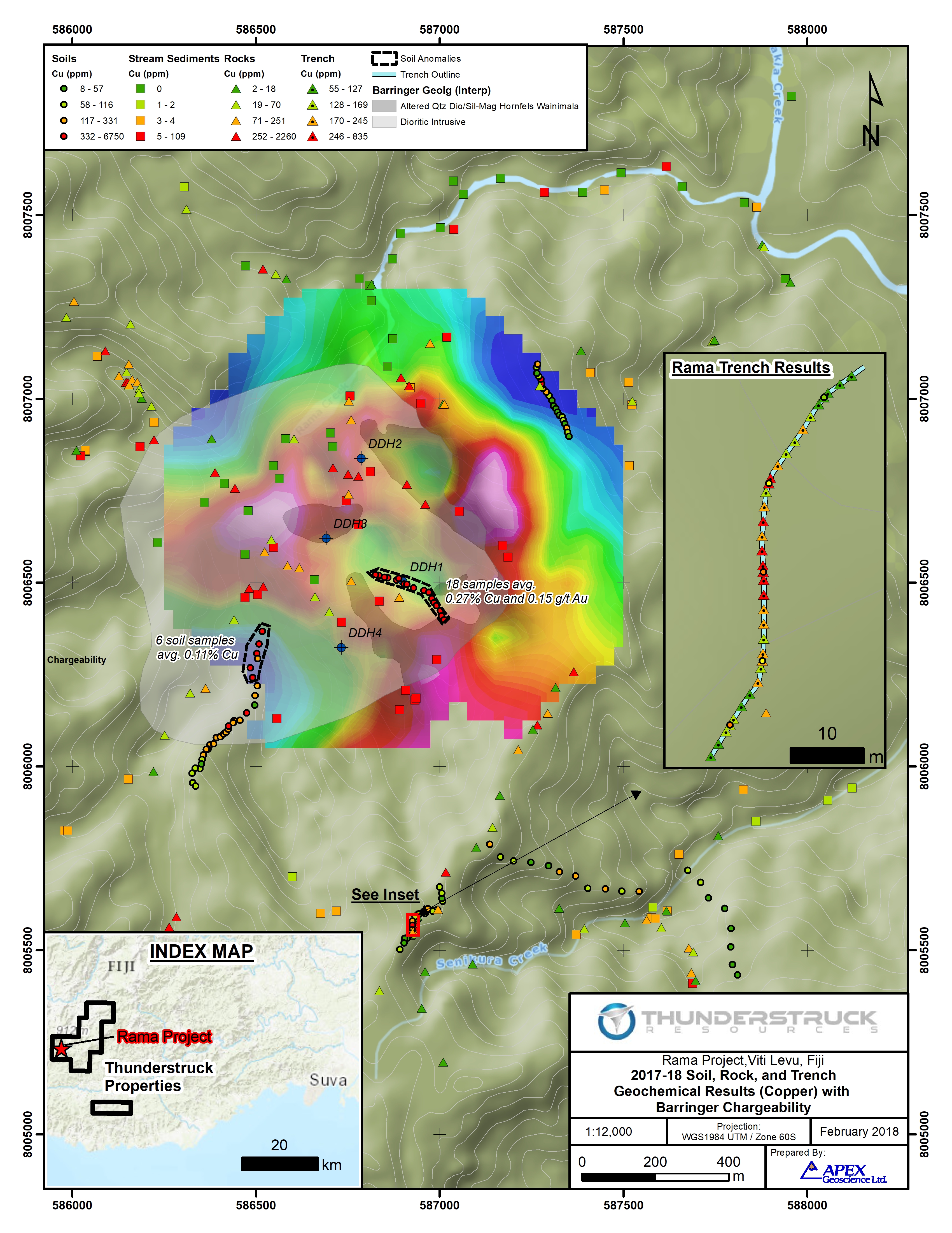
Figure 2
To view an enhanced version of this graphic, please visit:
https://orders.newsfilecorp.com/files/2901/33221_thunderstruckfig2enhanced.jpg
Along the interpreted southern margin of the porphyry, 600 m to the south of DDH1, a series of 31 auger soil samples collected over 500 m along a north trending ridgeline transect the mapped edge of the intrusion. Progressing northward from the interpreted southern edge of the intrusion, a total of 23 auger soil samples collected over 400 m averaged 452 ppm Cu. The northernmost six (6) auger soil samples collected over a distance of 120 m in an area flanked by thick alluvium returned an average of 0.11% Cu, with individual values ranging from 331 ppm Cu up to 0.23% Cu in soil.
Table 1 — 2017 Rama Creek Prospect Trench* Channel Sample Results
| Sample ID | From (m) | To (m) | Width (m) | Au (g/t) | Composite Grade | |
| 278741 | 0.0 | 2.0 | 2.0 | 0.082 | ||
| 278742 | 2.0 | 4.0 | 2.0 | 0.062 | ||
| 278743 | 4.0 | 6.0 | 2.0 | 0.112 | ||
| 278746 | 6.0 | 8.0 | 2.0 | 0.124 | ||
| 278747 | 8.0 | 10.0 | 2.0 | 0.172 | ||
| 278748 | 10.0 | 12.0 | 2.0 | 0.134 | ||
| 278749 | 12.0 | 13.5 | 1.5 | 0.29 | 0.55 g/t Au over 37.6 m | |
| 278750 | 13.5 | 15.4 | 1.9 | 0.317 | ||
| 278753 | 15.4 | 17.6 | 2.2 | 0.34 | ||
| 278754 | 17.6 | 19.0 | 1.4 | 0.295 | ||
| 278755 | 19.0 | 21.0 | 2.0 | 0.373 | ||
| 278756 | 21.0 | 23.0 | 2.0 | 0.303 | ||
| 278757 | 23.0 | 25.0 | 2.0 | 0.372 | ||
| 278758 | 25.0 | 27.0 | 2.0 | 0.492 | ||
| 278761 | 27.0 | 29.0 | 2.0 | 0.453 | ||
| 278762 | 29.0 | 31.0 | 2.0 | 0.663 | ||
| 278763 | 31.0 | 33.0 | 2.0 | 0.405 | ||
| 278764 | 33.0 | 34.6 | 1.6 | 0.358 | ||
| Boulder | 34.6 | 34.8 | 0.2 | |||
| 278765 | 34.8 | 37.0 | 2.2 | 0.311 | ||
| 278766 | 37.0 | 38.5 | 1.5 | 0.32 | ||
| 278767 | 38.5 | 39.7 | 1.2 | 0.601 | 0.96 g/t Au over 11.1 m | |
| 278768 | 39.7 | 42.0 | 2.3 | 2.45 | ||
| 278769 | 42.0 | 44.0 | 2.0 | 0.778 | ||
| 278770 | 44.0 | 46.0 | 2.0 | 0.582 | ||
| 278771 | 46.0 | 48.0 | 2.0 | 0.376 | ||
| 278772 | 48.0 | 49.6 | 1.6 | 0.483 | ||
| 278773 | 49.6 | 51.0 | 1.4 | 0.1 | ||
| 278774 | 51.0 | 53.0 | 2.0 | 0.048 | ||
| 278777 | 53.0 | 55.0 | 2.0 | 0.048 | ||
| 278778 | 55.0 | 57.0 | 2.0 | 0.027 | ||
| 278779 | 57.0 | 59.0 | 2.0 | 0.023 | ||
In addition, ten (10) auger soils collected over a 100 m distance spanning the contact zone of the intrusion returned anomalous gold values averaging 0.063 g/t Au (63 ppb Au); including two samples returning 0.1 and 0.2 g/t Au. The nature of this gold in soil anomaly bears similarity to the Senikura West gold target located 700 m to the southeast; as well as that of the broad historic Senikura East gold in soil anomaly located a further 1.5 km to the southeast (12 consecutive 100 m spaced auger soils over 1.2 km returning an average of 67 ppb Au). Based on the orientation of northwest-southeast trending creek drainages and historic geophysical interpretation, it's possible the two anomalies are related to a zone (or zones) of structurally controlled gold mineralization along the margin of the Rama Creek porphyry.
Exploration by Barringer Fiji Ltd. (Barringer) prior to 1974 at Rama Creek defined an approximately 1 km diameter composite quartz-diorite porphyry stock regionally assigned to the Tholo Plutonic Suite. Barringer collected a total of 469 soil geochemical samples at 60 m intervals at Rama Creek along a series of 100 m spaced northwest-southeast trending gridlines. The survey defined an approximately 800 m diameter greater than 400 ppm Cu in soil geochemical anomaly surrounded by a peripheral halo of anomalous zinc values. The historic copper anomaly is cut off sharply to the north by volcanic derived colluvium, to the east by a steep ridge, and to the south and west by thick alluvium. Within the centre of the anomaly, quartz-diorite porphyry rocks and Wainimala Volcanic Group rocks they intrude are highly altered to an assemblage of silica-sericite-chlorite-pyrite-magnetite, and locally secondary biotite. Mineralization consists of disseminated and fine fracture controlled pyrite-chalcopyrite-bornite and covellite. Historic Induced Polarization (IP) / Resistivity and ground magnetic surveys, also by Barringer, reveal distinct concentric chargeability and conductive anomalies about the margin of the copper anomaly. Within the core of the anomaly altered and mineralized porphyry intrusive rocks are resistive and locally strongly magnetic.
Stream BLEG and Prospecting Rock Samples
As a follow-up to the initial BLEG stream sampling program at Rama Creek (see the Company's September 27, 2017 News Release) Thunderstruck collected an additional 35 BLEG stream sediment samples in the headwaters of Rama and Senikura Creeks draining the Senikura West gold target area. (Bulk Leach Extractable Gold, more commonly shortened to BLEG, is a geochemical sampling/analysis tool used for gold exploration.) In conjunction with the results of 110 BLEG stream sediment samples already released for the Rama Creek Prospect, a total of eight (8) samples returned greater or equal to 13 ppb Au (>95th percentile); and six (6) samples greater than or equal to 6.4 ppm Cu (>95th percentile).
At the centre of the Rama Creek porphyry, a single BLEG stream collected 200 m downstream from Anglo drill hole DDH1 returned 0.1 g/t Au and 109 ppm Cu, the highest gold and copper BLEG stream value returned to date on the Project.
Combined, the 145 BLEG stream sediment samples collected to date define >95th percentile gold and copper anomalies within streams draining the core of the Rama Creek Cu-Au porphyry target, and >95th percentile gold anomalies within streams draining west and east of the Senikura West gold target. A total of two (2) separate drainages west of Rama Creek returned BLEG stream values of 18 ppb Au; and 13 and 14 ppb Au, respectively and may represent as yet unknown gold targets (Figure 1).
Surface rock grab sample results represent both in-situ outcrop and loose creek flat material. The majority of rock grab samples were collected from narrow immature drainages, and as such transport distance of float rock material is considered to be short. In general outcrop in the Rama Creek area is limited, particularly in the area of historic drilling, with sporadic outcrop exposures present in scoured creek beds, and as positive relief features along ridgetops. Of the 102 rock grab samples collected to date at Rama Creek a total of 12 returned greater than 500 ppm Cu and are considered anomalous. Of the 12 rock grab samples, 6 samples returned greater than 0.1% Cu and up to 0.26% Cu. Of the 102 rock grab samples, a total of 6 samples returned greater than 0.1 g/t Au (up to 0.24 g/t Au) and are considered anomalous (Figure 1).
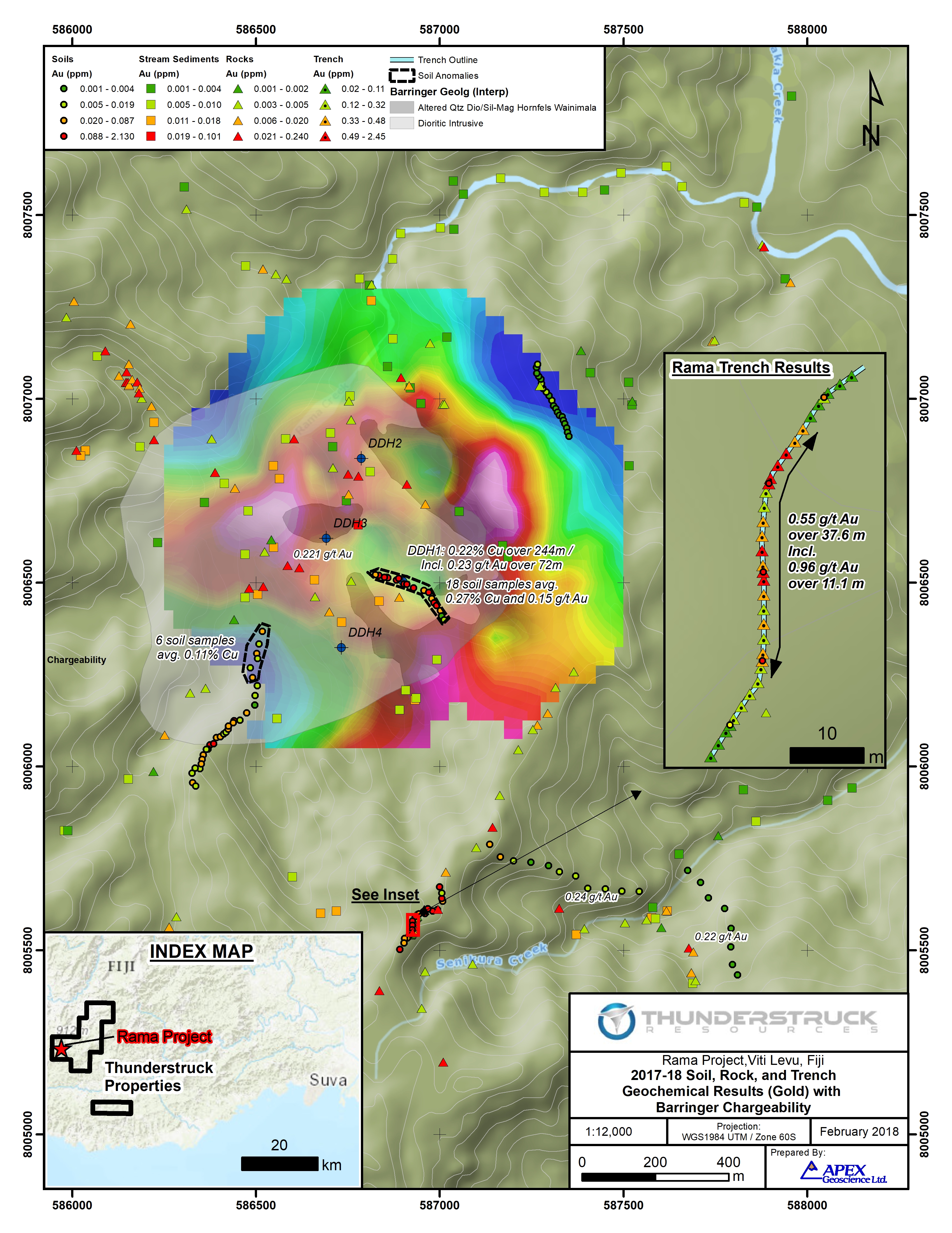
Figure 1
To view an enhanced version of this graphic, please visit:
https://orders.newsfilecorp.com/files/2901/33221_thunderstruckfig1enhanced.jpg
Interpretation
The work by Thunderstruck and previous operators at Rama Creek has confirmed the presence of a 1 km diameter composite quartz-diorite copper-gold mineralized porphyry intrusive stock. Intensely silica-sericite (±biotite) altered porphyry is surrounded by a highly chargeable magnetite-pyrite-chlorite shell within less altered diorite and host Wainimola Volcanic rocks. The full extent of mineralization is obscured to the north by volcanic colluvium and to the south by thick alluvial deposits. Current auger soil geochemical sampling and surface trenching by Thunderstruck has resulted in the discovery of peripheral zones of broad, possibly structurally controlled, gold mineralization. Limited trenching to date has yet to define the north-south limits of the Senikura West gold zone, and a separate possibly related gold in soil geochemical anomaly 700 m to the northwest has yet to be tested by trenching.
Moving forward, Thunderstruck plans to continue advancing the Rama Creek porphyry gold-copper prospect through completion of early 2018 IP/Resistivity surveys towards modelling the subsurface geometry of disseminated sulphide mineralization and generation of finalized diamond drill targets. In addition, further evaluation is planned of the numerous spatially associated gold targets.
Financing
The Company has arranged a non-brokered private placement to raise up to $400,000 through the sale of up to 5,000,000 units at a price of $0.08 per unit (the "Financing"). Each unit will comprise one common share and one share purchase warrant. Each whole warrant will entitle the holder to purchase a further common share at a price of $0.15 per share for a period of 36 months from closing. The warrants will be subject to accelerated exercise provisions such that if the closing price of Thunderstruck's common shares exceeds $0.25 per share for a period of 20 consecutive trading days, Thunderstruck may give notice of the acceleration of the warrants' term to a period of 30 days following such notice. Proceeds of the Placement will be applied to continuing operations on the Company's Fiji properties and general working capital.
About Thunderstruck Resources
Thunderstruck Resources is a Canadian mineral exploration company that has assembled extensive and highly prospective properties in Fiji on which recent and previous exploration has confirmed VMS, copper and precious metals mineralization. The Company provides investors with exposure to a diverse portfolio of exploration stage projects with potential for zinc, copper, gold and silver in a politically safe and stable jurisdiction. Thunderstruck trades on the Toronto Venture Exchange (TSX-V) under the symbol "AWE".
Qualified Person Statement
Kristopher J. Raffle, P.Geo. (BC) Principal and Consultant of APEX Geoscience Ltd. of Edmonton, AB, is a qualified person for the project as defined by National Instrument NI 43-101. Mr. Raffle has reviewed the portion of the technical content of this news release as it relates to the Liwa Creek Prospect.
During 2017 all stream sediment samples were submitted to Australian Laboratory Services Pty. Ltd (ALS) labs Perth for BLEG determination of gold, copper and silver. Auger soil samples were submitted for gold and multi-element geochemical analysis via a 25 gram (g) sample split subject ICP-MS. Prospecting and trench rock samples submitted for 30g gold Fire-Assay analysis and multi-element geochemistry by four-acid ICP-ES. Thunderstruck has relied on the external QA/QC of ALS which included the insertion of insertion of standard, blank and duplicate samples at a rate of 10% into the sample stream to confirm the accuracy of the reported results.
*Surface trenches were dug by hand to a maximum depth of 1m into saprolite with the goal of reaching weathered in-situ bedrock approximating the B/C soil profile transition. In all cases where the B/C transition was reached pervasively clay altered saprolite rock present often showing relict primary textures, alteration and mineralization in the form of weathered sulphide minerals.
For additional information, please contact:
Bryce Bradley, President, Chief Executive Officer and Director
Telephone: (604) 349-8119
Email:This email address is being protected from spambots. You need JavaScript enabled to view it.
or, visit our website: http://www.thunderstruck.ca
Neither the TSX Venture Exchange Inc. nor its Regulation Services Provider (as that term is defined in the policies of the TSX Venture Exchange) accepts responsibility for the adequacy or accuracy of this release.
This news release contains certain statements that may be deemed "forward-looking statements". Although Thunderstruck believes the expectations expressed in such forward-looking statements are based on reasonable assumptions, such statements are not guarantees of future performance and actual results may differ materially from those in forward looking statements. Forward looking statements are based on the beliefs, estimates and opinions of Thunderstruck's management on the date the statements are made. Except as required by law, Thunderstruck undertakes no obligation to update these forward-looking statements in the event that management's beliefs, estimates or opinions, or other factors, should change.
Vancouver, British Columbia--(Newsfile Corp. - February 13, 2018) - Thunderstruck Resources Ltd. (TSXV: AWE) ("Thunderstruck") is pleased to provide results from its recent exploration conducted at the Liwa Creek Gold Prospect in late 2017.
Liwa Creek is part of a 148 sq km property held by Thunderstruck in Fiji, located 50km south of the Vatukoula gold mine, which has produced 7 million ounces of gold. Fiji is located on the Pacific Ocean's Ring of Fire, which contains many of the world's major gold and copper deposits, including Lihir and Grasberg *.
Between November and December 2017 Thunderstruck crews completed 520m of hand trenching in four (4) separate areas of the Jensen and Liwa Ridge gold showings resulting in the collection of 117 trench channel samples. In addition, 123 prospecting rock grab, 110 ridge-and-spur auger soil, and 47 BLEG stream sediment samples were collected from the Liwa and Vatuvatulevu creek areas, which include the Liwa Ridge, Jensen's, and Gun gold showings.
Commenting on the results, President/CEO Bryce Bradley notes that "Multiple examples of significant gold mineralization, as well as extensive anomalies, have now been uncovered across the expanse of our property. In particular, these results show that our Liwa and Jensen's discoveries are shaping up to be intriguing gold targets. Now that we have all permitting in place, we're entertaining joint venture opportunities to aggressively advance this exciting asset."
Jensen's Showing
Thunderstruck prospecting crews successfully located and sampled the historic Jensen's gold showing on Wainamoli Creek with two rock grab samples returning high grade gold values of 36.1 and 31.8 g/t Au; including 12.5% and 6.8% Pb (lead), respectively (Table 1). A total of 21 rock grab samples were collected along a stretch of the Wainamoli Creek outlining a 300m zone of anomalous gold values; including 8 samples returning greater than 0.2 g/t Au, and a series of discontinuous rock outcrop channel samples collected over a distance of 35m averaging 0.38 g/t Au.
Table 1: 2017 Liwa Creek Prospect Significant Rock Grab Sample Results
| Sample ID | Area | Au g/t | Ag g/t | Pb % |
| 278521 | Jensen's | 36.10 | 18.7 | 12.5 |
| 278522 | 31.80 | 22.2 | 6.8 | |
| 278529 | 1.08 | - | 0.1 | |
| 278381 | 0.46 | - | 0.1 | |
| 278368 | Liwa Ridge | 8.13 | - | 0.2 |
| 17KRP901 | 3.30 | - | 0.2 | |
| 278363 | 1.66 | - | - | |
| 17KRP903 | 0.86 | - | - | |
| 278316 | 0.52 | - | - | |
| 278528 | 0.51 | - | - | |
| 278394 | Noda Creek | 3.54 | - | 0.1 |
| 278274 | 1.27 | 12.6 | - | |
| 278338 | Lower Vatuvatulevu | 1.69 | - | 0.3 |
| 278335 | 1.01 | - | - | |
| 278351 | Gun | 0.44 | 25.5 | - |
Excavation of a 261m E-W trending trench at the Jensen's gold showing was hampered by deep weathering along the western half of the trench and deep stream gravels along Wainamoli Creek. The 29.1m interval between 189.5 and 218.6 m uncovered a zone of weathered locally quartz-sulphide mineralized and intensely sericite altered and limonitic mafic volcanic rock. The highest trench value within this interval returned 0.1 g/t Au over 2.8m.
The relationship of the trenched intervals to the true width of mineralization is not known. However, field relationships suggest mineralized zones may trend NE to ENE sub-parallel to the major drainage of Wainamoli Creek. Anomalous gold values within Jensen's trench are therefore interpreted to define the western limits of a poorly exposed zone of locally high grade gold mineralization to the east.
Liwa Ridge Showing
At the Liwa Ridge Showing two trenches (Liwa North and South) were excavated having lengths 124m and 110m, respectively; separated 200m along strike and 100m vertically.
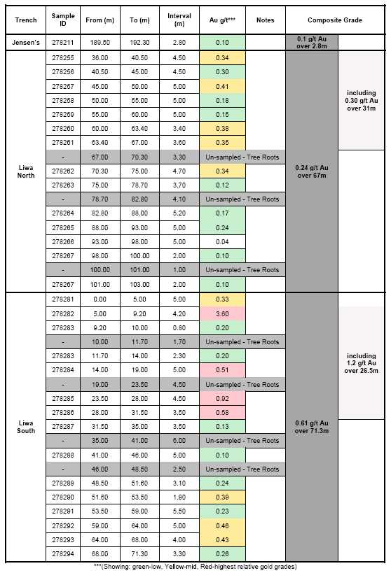
The Liwa South trench returned, 1.2 g/t Au over 26.5m (from 5 to 31.5m, 6.2m un-sampled*), including 3.6 gram-per-tonne (g/t) gold (Au) over 4.2m (from 5 to 9.2m), within a broader anomalous gold zone averaging 0.61 g/t Au over 71.3m (from 0 to 71.3m, 14.7m un-sampled). Mineralization is open to the east with the first trench sample returning 0.33 g/t Au over 5m (Table 2).
The Liwa North trench returned 0.30 g/t Au over 31m (from 36 to 67m) within a broader anomalous gold zone averaging 0.24 g/t Au over 67m (from 36 to 103m, 8.4m un-sampled). Mineralization is open to the east under thick scree cover. To the west the trench crosses the 6m wide Liwa Creek drainage. Limited trench sampling on the west side of Liwa Creek did not return anomalous gold values, however select outcrop grab samples there yielded anomalous gold values of 0.11, 0.15 and 0.52 g/t Au.
Geologic mapping confirms the presence of a sub-vertical 60m wide zone of hematite-silica-pyrite altered mafic volcanic rocks over a 400m strike and 100m vertical extent between the Liwa and Noda creek drainages. The zone is open to the north, south and east under scree and soil cover.
A total of 46 rock grab samples were collected over a 600 x 200 m area surrounding the Liwa Ridge showing. Gold values ranged from below detection up to 8.13 g/t Au and 0.19% Pb, with a total of 7 samples returning greater than 0.5 g/t Au. Prospecting has extended gold mineralization 120m south of Liwa Ridge into the Noda Creek drainage where rocks grab sampling returned values of 1.27 and 3.54 g/t Au in outcrop.
Auger soil sampling along Liwa Ridge revealed robust gold in soil values (0.64 g/t Au) coincident with trench-confirmed mineralization. An additional two auger soils collected at distances of 5 and 20m beyond the eastern limit of the Liwa South trench returned 0.24 and 0.55 g/t Au, respectively (the three highest gold-in-soil values to date); indicating potential to expand the mineralized zone eastward.
Table 2 - 2017 Liwa Creek Prospect Significant Trench Channel Sample Results**

Cannot view this image? Visit:
http://orders.newsfilecorp.com/files/2901/32760_table2.jpg
Gun Showing
The Gun Showing occurs on a remote north-south tending ridge in the headwaters of Vatuvatulevu Creek. Historic rock outcrop sampling at Gun returned 700 ppb Au, in association with quartz-sulphide rock float located in a tributary 300m to the northwest returning 12 g/t Au and 110 g/t Ag (silver). Current rock grab sampling within the tributary and along Gun Ridge comprised 21 samples, with six samples returning greater than 0.10 g/t Au. Rock float at the Gun Showing returned 0.44 g/t Au, including 25.5 g/t Ag; and 0.32 g/t Au. Rock float samples from the tributary returned 0.46 g/t Au including 0.12% Pb and 0.30 g/t Au.
A single reconnaissance auger soils line comprising 21 samples spaced at 10m intervals trending southwest from the Gun Showing returned highly anomalous gold values. A total of 12 continuous auger soil samples collected over a distance of 110m returned an average of 28 ppb (parts-per-billion) Au, and up to 82 ppb Au, the highest gold in soil value of 110 samples returned on the Project outside three contiguous samples collected over the Liwa Ridge gold zone. Within the Liwa Creek Prospect, auger soil samples returning greater than 20 ppb Au are considered highly anomalous.
The Company considers the results of auger soil, rock grab and stream sampling at the Gun Showing significant in that they demonstrate anomalous gold values over a 300m distance that remain open to the north, south and east in this remote and under-explored region of the Prospect.
Stream BLEG Sampling
A total of 47 BLEG (Bulk Leach Extractable Gold) stream sediment samples were collected over a 3 x 2 km area of Liwa and Vatuvatulevu creeks. A total of 19 of 47 stream samples returned BLEG cyanide leach gold values in excess of 10 ppb Au and are considered anomalous. Of the 47 samples, a total of 10 samples returned greater than of 30 ppb Au, and up to 78 ppb Au. Anomalous stream samples define three (3) high-priority areas for follow-up prospecting: Liwa Ridge, Lower Vatuvatulevu Creek and the Gun Showing area.
A total of seven (7) highly anomalous stream sediment samples collected from Liwa and Noda creeks averaged 48 ppb Au. The entire 1.5 km length of Noda Creek returned anomalous gold values (ranging from 34 to 78 ppb Au) from its headwaters where outcrop rock grab samples returned up to 3.54 g/t Au downstream to its confluence with Wainamoli Creek. Stream sampling results flanking the Liwa Showing indicate significant potential to extend the mineralized zone eastwards in agreement with auger soil sampling results and 900m south into the Noda Creek drainage.
Within Lower Vatuvatulevu Creek, two eastern tributaries returned BLEG values of 49 and 45 ppb Au and a third returning 19 ppb Au. Angular rock float samples of brecciated and banded quartz-pyrite mineralized rock with 49 ppb Au returned values of 1.7 g/t Au including 0.32% Pb, and 1 g/t Au. Historic stream float rock returning 6.4 g/t Au with no known bedrock source was reported along this stretch of Vatuvatulevu Creek. The Lower Vatuvatulevu Creek gold in stream anomaly is located 650 east along the inferred strike of Jensen's Showing high grade gold rock samples.
In the headwaters of Vatuvatulevu Creek, a tributary 300m northwest of the Gun Showing returned BLEG stream values of 28 and 29 ppb Au, indicating potential to extend mineralization further north at this newly developed prospect. Additional stream BLEG, auger soil and prospecting is considered a high priority as major drainages to the east and a prominent north-south trending ridgeline there remain to be evaluated.
Interpretation
The work by Thunderstruck, building on the work by previous operators, has identified gold mineralization over an area of 3 km by 3 km. Samples from outcrops and trenches at Jensens and Liwa Ridge demonstrate the potential for the system to carry favourable grades, while the soil and BLEG samples at the other prospects demonstrate the presence of gold over a large area, suggesting the presence of a large mineralizing system, on a scale comparable to other large gold-bearing systems in the Pacific Rim of Fire.
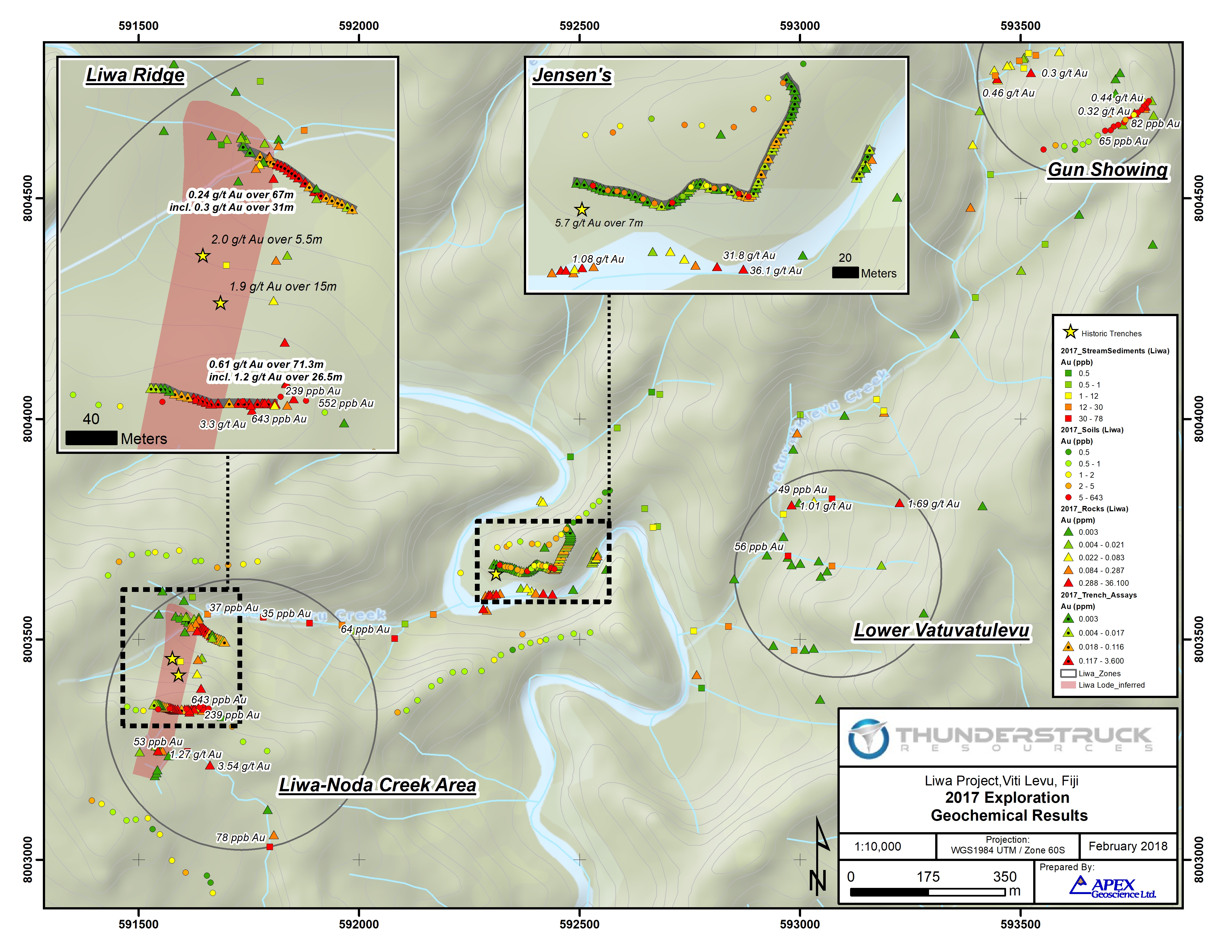
Liwa Exploration Geochemical Results
To view an enhanced version of this graphic, please visit:
http://orders.newsfilecorp.com/files/2901/32760_map.jpg
About Thunderstruck Resources
Thunderstruck Resources is a Canadian mineral exploration company that has assembled extensive and highly prospective properties in Fiji on which recent and previous exploration has confirmed VMS and Precious Metals mineralization. The Company provides investors with exposure to a diverse portfolio of exploration stage projects with potential for zinc, copper, gold and silver in a politically safe and stable jurisdiction. Thunderstruck trades on the Toronto Venture Exchange (TSX-V) under the symbol "AWE".
Qualified Person Statement
Kristopher J. Raffle, P.Geo. (BC) Principal and Consultant of APEX Geoscience Ltd. of Edmonton, AB, is a qualified person for the project as defined by National Instrument NI 43-101. Mr. Raffle has reviewed the portion of the technical content of this news release as it relates to the Liwa Creek Prospect.
During 2017 all stream sediment samples were submitted to Australian Laboratory Services Pty. Ltd (ALS) labs Perth for BLEG determination of gold. Auger soil samples were submitted for gold and multi-element geochemical analysis via a 25 gram (g) sample split subject ICP-MS. Prospecting and trench rock samples submitted for 30g gold Fire-Assay analysis and multi-element geochemistry by four-acid ICP-ES. Thunderstruck has relied on the external QA/QC of ALS which included the insertion of insertion of standard, blank and duplicate samples at a rate of 10% into the sample stream to confirm the accuracy of the reported results.
*Not necessarily indicative of mineralization on Thunderstruck Properties
**Surface trenches were dug by hand to a maximum depth of 1m into saprolite with the goal of reaching weathered in-situ bedrock approximating the B/C soil profile transition. In all cases where the B/C transition was reached pervasively clay altered saprolite rock present often showing relict primary textures, alteration and mineralization in the form of weathered sulphide minerals. Given the hand-excavated nature of the trenches and heavy forest cover at Liwa Creek continuous ground sampling was often not possible due to the presence of tree root masses. As such trench results are presented with sample width and assay data including all un-sampled intervals.
For additional information, please contact:
Bryce Bradley, President, Chief Executive Officer and Director
Telephone: (604) 349-8119
Email:
or, visit our website: http://www.thunderstruck.ca
Neither the TSX Venture Exchange Inc. nor its Regulation Services Provider (as that term is defined in the policies of the TSX Venture Exchange) accepts responsibility for the adequacy or accuracy of this release.
This news release contains certain statements that may be deemed "forward-looking statements". Although Thunderstruck believes the expectations expressed in such forward-looking statements are based on reasonable assumptions, such statements are not guarantees of future performance and actual results may differ materially from those in forward looking statements. Forward looking statements are based on the beliefs, estimates and opinions of Thunderstruck's management on the date the statements are made. Except as required by law, Thunderstruck undertakes no obligation to update these forward-looking statements in the event that management's beliefs, estimates or opinions, or other factors, should change.
- Thunderstruck Provides Exploration Update, Appoints Lawrence Roulston and Linnea Von Hessert to Board
- Thunderstruck Mobilizes Crews to Liwa Creek
- Thunderstruck Announces Results of Stream Sediment Sampling at Rama Creek Porphyry Cu-Au Prospect
- Thunderstruck Engages Apex Geoscience Ltd to Oversee Exploration in Fiji and Provides Progress Report